
The Origins and History of Potters Bar
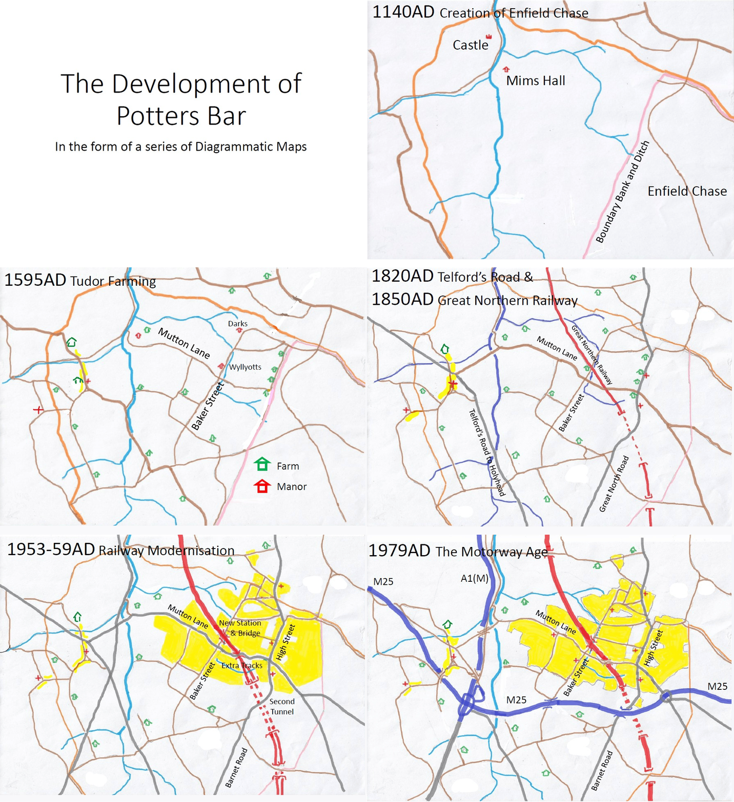
Here is a republication of Nick Alexander’s excellent article on this origin and history of Potters Bar. This was accompanied with some sketches of maps from the period. These have been animated below.
THE ORIGINS AND HISTORY OF POTTERS BAR
Formation of Middlesex and Hertfordshire
The development of Potters Bar into the town as we know it today has been influenced by a surprising range of factors. The first of these was the negotiations between the Anglo-Saxon Kingdom of Mercia, covering Middle England, and the Saxon Kingdom of Essex, covering the area north of the Thames between London and the North Sea. In the year 704, these resulted in the definition of the boundary between Middlesex and Hertfordshire which, in our area at least, remained unchanged for over 1250 years.
In our area, the boundary agreed in 704 followed an S-shaped route with an area of Middlesex intruding into Hertfordshire in the north and an area of Hertfordshire penetrating into Middlesex to the south. It appears that the Church, and future Abbey, at St Albans already owned land at Northaw and at Southaw and wanted both to remain in Hertfordshire. Middlesex was allowed to claim the area in between these two land holdings. Southaw included modern-day Chipping Barnet, Barnet Vale, New Barnet and East Barnet.
Creation of Enfield Chase
The next significant change was the creation of Enfield Chase as a kind of Conservation Area in 1140. Its northern boundary coincided with the County Boundary and its western boundary followed a ridge of high ground southwards to Monken Hadley. This left the area now covered by South Mimms and Potters Bar effectively cut off from the rest of Middlesex.
Chipping Barnet
In 1199, Chipping Barnet won the right to hold regular markets and this created the need for a better road link between Barnet and St Albans. Using their modern names, the route chosen for this new link was along Kitts End Road to Dancers Hill, down Wash Lane, along one of the southern tributaries of Mimmshall Brook, up Greyhound Lane, along the north end of Blanche Lane and then along Blackhorse Lane to London Colney. The need for travel facilities along this route led to the village of South Mimms being established and, by about 1250, parts of St Giles church had been built forming the first place of worship in our area of Middlesex.
Wyllyotts Manor
It is evident that, by this time, a number of clearings and farms had been created in the formerly wooded area west of Enfield Chase and, in 1349, there is the first mention of Wyllyotts Manor. This is followed by the first mention, in 1387, of Potters Barr, not as a place, but as a gate leading into Enfield Chase and located where the western boundary of the Chase joined the County Boundary, outside the entrance to Morven. From the Potters Barr gate, a track followed the line of the modern-day Causeway to the Chequers Inn at Coopers Lane and then along the common Chase and County Boundary towards Crews Hill.
Potters Bar begins to form
In 1490, there is the first mention of a second farm in the area now occupied by the built-up area of Potters Bar. This was Darks, a moated farm-house on the site of the modern Cedar Close. A Century later, a detailed map of Wyllyotts Manor in 1594 shows several roads which we recognise today even though the map does not name them. These include Baker Street, Mutton Lane (labelled as “The Way from Mymhall to the Chase”), Quakers Lane (labelled as “The Way to Potters Barr”) and Billy Lows Lane (labelled as “The New Lane to the Chase”). Many of the field boundaries shown on the 1594 map had not changed when the first detailed Ordnance Survey map was produced in 1868.
A route to the North
By 1690, Barnet became the preferred route out of London to the Midlands, instead of the old Roman road of Watling Street via Edgware. This encouraged further growth at South Mimms. Barnet also became the preferred route to the North, instead of the old Roman road of Ermine Street via Edmonton, and the new route north of Barnet was via Baker Street, Quakers Lane and left onto Colliers Lane to Little Heath and so on to Hatfield.
Although this route through our area was shown as the way to Hatfield and York, there is no evidence of there ever having been coaching inns along Baker Street and Darkes Lane. Instead, an inn named “The Swan with two Necks” was established in what would later become Potters Bar High Street in 1658 and this was followed by the Green Man in 1672.
Turnpike Trusts
As in every parish along these long-distance routes, the local people were supposed to maintain the roads but as traffic increased this proved an impossible task. To overcome this problem, Turnpike Trusts were created in which new toll roads were built with better all-weather surfaces and travellers were charged for using them.
The first such Turnpike in our area was from Barnet along the east side of Wrotham Park to Ganwick Corner (now known as The Duke of York). This was extended in 1730 generally following the boundary of Enfield Chase to reach the corner and the gate still known as Potters Barr. From there, travellers could turn west along Quakers Lane and then right onto Colliers Lane to Little Heath, or they could turn east onto The Causeway and then left onto Coopers Lane before looping back to join London Lane at Swanley Bar.
New Developments
By 1754, Roque’s detailed map of Middlesex showed several more developments along the west side of the High Street. These would have housed the blacksmiths and the shoemakers who were so necessary in addition to the catering and accommodation facilities at the inns and to the stables providing fresh horses. Roque shows the name Potters Barr alongside these developments and this may be taken as the first time that the name is associated with a place rather than just a gate. This map is also the first to name Baker Street and Mutton Lane.
In 1780, Enfield Chase, which had served its role as a Conservation Area for flora and fauna for almost 650 years, was broken up and a strip of land about one kilometre wide along its western boundary was transferred into South Mimms parish. This created the opportunity for the first time for development along the east side of Potters Bar High Street. One of the ancient rides through the Chase was extended from the top of Stagg Hill to become Southgate Road, providing a second route out of London to the Midlands and the North.
Hatfield Road
In 1805, Hatfield Road was constructed from the Green Man to Little Heath and the Turnpike was extended to Hatfield via Swanley Bar and Bell Bar. Colliers Lane fell out of use, with no trace of it remaining, and Baker Street dropped back from its short-lived importance as part of the Great North Road into its former role as a farm access track.
The Great Northern Railway and Potters Bar station
In 1850, the Great Northern Railway opened through our area. For some years, until the direct route from Peterborough to Doncaster via Grantham was completed, the bridge over what is now Darkes Lane was the highest point of the railway anywhere between London and York and the adoption of a low girder bridge in preference to a high arch greatly reduced the earthworks required on the long climb through Barnet and Hadley Wood.
The provision of a railway station in our area was very much an afterthought and it was not even complete when the railway opened. Its considerable distance from both South Mimms and the small community at Potters Bar High Street made it difficult to choose an appropriate name for the station. It went through several changes before becoming plain Potters Bar. During its first hundred years of operation, the station acquired all the facilities required to serve what was still a predominantly rural farming area.
As first built, the railway was double-track but within thirty years it had been widened to four tracks from London as far as Hadley Common and from Potters Bar station northwards. The remaining double-track section through the three tunnels between Hadley Common and Potters Bar was deemed too expensive to widen and this severe operational bottleneck prevented the introduction of a frequent commuter service to London for over one hundred years. As a result, the coming of the railway did not provide the impetus for house-building around Potters Bar station as it did in many other places.
Potters Bar begins to grow in size
Instead, most new developments in the second half of the 19th Century and in the early years of the 20th Century were concentrated around the Great North Road (Barnet Road, the High Street and Hatfield Road). These included new roads with large Victorian Villas or mini-mansions and other areas with rows of smaller artisan cottages. The cachet of a Hertfordshire address also encouraged building in Little Heath but after 1900 developments, mainly of detached houses, were beginning at the north end what was still known as Baker Street.
Darkes Lane
North of where it crossed Mutton Lane, Baker Street was re-named as Darkes Lane early in the 1930s after the former South Mimms Parish Council had been replaced by the Potters Bar Urban District Council, reflecting the change in importance between the two communities.
North of the railway bridge, an open stream ran along the east side of Darkes Lane as far as a ford, with a footbridge beside it, just before the junction with Billy Lows Lane. Most of this stream was culverted over in the 1930s and is the reason for the wide pavement on the east side of Darkes Lane between The Walk and Byng Drive. The section of the stream nearest to, and beside, the railway was not culverted until the 1960s and is under the access road outside McDonalds.
Post WWII development
Apart from either side of the High Street and east of Barnet Road, the whole area from Quakers Lane in the north to Wrotham Park in the south and from South Mimms in the west to the new parish boundary in the east was still green fields until the end of the First World War. In the following decade, there were a number of small developments but, from 1928 until the outbreak of the Second World War, the town would change out of all recognition.
New residential building in this period was a mixture of semi-detached houses and bungalows plus a few blocks of flats and maisonettes. Some developers, like Mr Hicks, offered a range of bungalow designs, including his chalet-style “bungalette”. Others concentrated on a more limited range of semi-detached houses. This period also saw the construction of new shops, schools, a cinema, and several churches to serve the rapidly expanding population.
Older buildings in the High Street and Barnet Road were torn down and replaced by modern shops and a completely new shopping centre was created in Darkes Lane. Work on this started on both sides of the Broadway between Mutton Lane and the railway bridge. The west side of Darkes Lane north of the railway was the next phase but the east side of Darkes Lane was not fully developed until after the Second World War.
Very few new houses were built during the Second World War and, after 1945, the only significant developments were in pre-existing projects, such as the second phase of the Auckland estates, Elmfield Road, Sunnybank and the Tempest Road area, all of which had been started but not completed by the end of 1939.
The 1950s and 1960s
The only remaining areas available for development in the 1950s and 1960s were relatively small estates such as behind the Fire Station, on the site of Dugdale Hill Farm and on the site of former Nursery Gardens at Sandringham Road within the town, or larger estates on the edge of town. The latter included the Ashwood Estate in the corner bounded by Barnet Road and Mutton Lane, the Oakmere Estate extending out to the eastern boundary of the town, estates north and south of The Causeway and the Kimptons Mead area.
Since then, new housing within the town has been limited to small developments in long back gardens and a few cases where large old houses have been demolished and replaced by a group of smaller dwellings.
Employment patterns have changed greatly since World War Two. Construction of a new station in the early-1950s and of new tunnels south of the town enabled a much-improved commuter service to London, and to the new town at Stevenage, but the introduction of family cars also opened up the possibility of commuting east and west as well as north and south.
A number of office blocks have been built in the town but provide employment for incomers as much as residents. As working patterns have changed, some of these blocks have been converted into residential flats. The introduction of supermarkets has made many of the traditional shops redundant and, as in many towns elsewhere, the main roads of The High Street and Darkes Lane have found a new existence through Charity Shops and Restaurants.
Future expansion will be dependent on relaxation of the Green Belt regulations which so far have created an effective boundary around the town and have had a major influence on its character and sense of community.
Nick Alexander